WDFW Beach Season Information
Clam, mussel, and oyster seasons OPEN for harvest year-round.
WDFW shellfish seasons indicate the specific times of year when harvesting is permitted. Before heading to the beach, please also check the Department of Health (DOH) information below which is related to health of the shellfish and may be updated daily. To harvest on this beach, it must be both during the WDFW approved season and approved by the DOH.
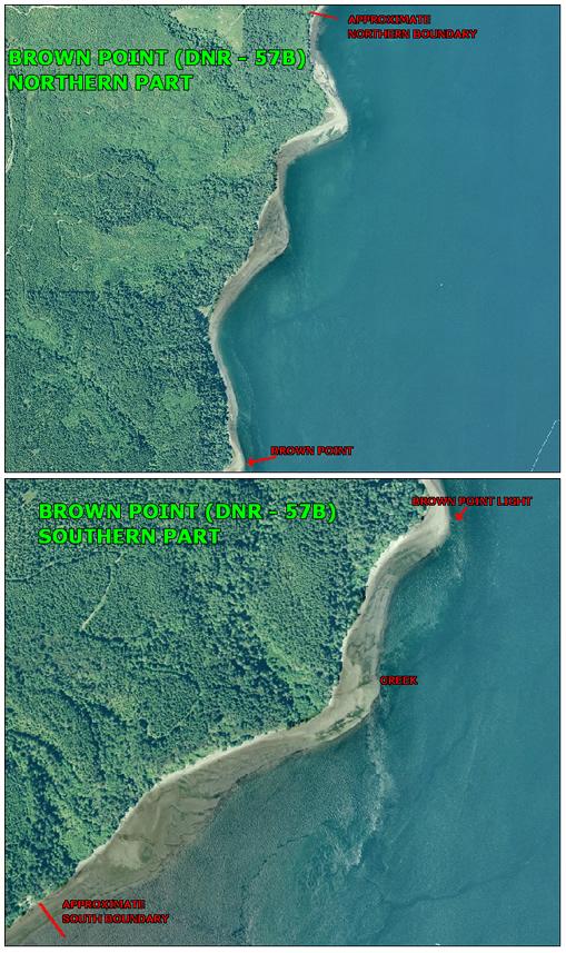
![]() DNR 57-B (Brown Point)
is accessible by boat only. There is no upland access to this beach.
DNR 57-B (Brown Point)
is accessible by boat only. There is no upland access to this beach.
This beach has good populations of horse clams, butter clams, native littleneck clams, Manila littleneck clams, geoducks, cockles and varnish clams. Some of the best littleneck digging is at Brown Point and near the old homestead south of Brown Point (see beach map), but clams can be found in most areas with mixed sand and gravel substrate.
Although it is possible to access this site by foot on gated, private timber company and U.S. Government roads, boat access is recommended. The closest boat ramps to this site are Misery Point Ramp, near Seabeck, Salsbury County Park Ramp, just north of the Hood Canal Bridge, the Termination Point Ramp, at the west end of the Hood Canal Bridge and at W.R. Hicks County Park in Squamish Harbor (ramp not recommended for large boats or for use during tides lower than plus five feet or so).
The approximate GPS coordinates for Brown Point are: 47.773205o N, 122.750148o W at the north boundary and47.7416o N, 122.77o W at the south boundary. The landmarks for the south boundary are two, 10-15 foot tall, rusty, metal posts just south of the old homestead (see beach map). There are no reliable landmarks at the north boundary. Use the GPS points provided above to determine the north boundary.
The old homestead is located south of Brown Point, at the base of an exposed bluff, where a small stream enters the canal (see beach map).
There are no facilities at Brown Point. The uplands are owned by the U.S. Navy and there are no houses or public roads.
Because of its solitary location, this site is a great place for observing wildlife, picnicking, and walking on the beach. There is a rough campsite at the north end of the beach.