WDFW Beach Season Information
Clam, mussel, and oyster seasons OPEN to harvest March 1 through April 30.
Recreational shellfish harvesting in the vicinity of the State Park boat dock in Mayo Cove is CLOSED year-round.
WDFW shellfish seasons indicate the specific times of year when harvesting is permitted. Before heading to the beach, please also check the Department of Health (DOH) information below which is related to health of the shellfish and may be updated daily. To harvest on this beach, it must be both during the WDFW approved season and approved by the DOH.
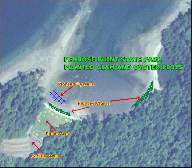
This beach has been enhanced with clams and oysters.
The best area for clam and oyster harvest on this beach is in the bay between Penrose Point and the small spit to the northwest of Penrose Point. This area has been enhanced with Manila clams and Pacific oysters. Native littleneck clams, butter clams, horse clams and eastern shoftshell clams are also found on this beach.
The innermost portion of Mayo Cove, including the park's boat dock, is CLOSED to recreational shellfish harvesting. Harvesting of shellfish within a Marina Closure Area may be hazardous to your health and is not advised.
From the south (Tacoma and SR 16), take the Purdy/SR 302 exit. Follow SR 302 south from Purdy for about 5 miles. Look for the turn onto Key Peninsula Highway. Turn left and follow Key Peninsula Highway through the town of Key Center (about 13 miles from Purdy). Continue about another three miles to Home. Turn left at Cornwall Road KPS (second road after crossing the Home Bridge). Continue about one and a quarter miles, and turn left onto 158th Avenue KPS. Follow this street into the park.
From the north (Bremerton, Silverdale), travel south on SR 3 to Gorst, where SR 3 merges with SR 16, and continue south on SR 3 for about 8 miles to Belfair. Travel through Belfair and look for the SR 302 exit just southeast of Belfair. Continue on SR 302 for about 10 miles to the intersection of SR 302 and Wright-Bliss Road. Turn right onto Wright-Bliss Road and travel south until Wright-Bliss Road becomes Vaughn Road at the town of Vaughn. Just after you pass through Vaughn, turn left on Lackey Road and proceed another 6 miles to the intersection of Lackey Road and Key Peninsula Highway. Take a left and follow Key Peninsula Highway for about two miles to Home. Turn left at Cornwall Road KPS (second road after crossing the Home Bridge). Continue about one and a quarter miles, and turn left onto 158th Avenue KPS. Follow this street into the park.
Penrose Point State Park offers camping, picnic areas, kitchen shelters, a boat dock, moorage floats, hiking and bike trails, horseshoe pits, and fire rings.